
A dangerous ice storm is spreading across the northern US, creating hazardous travel conditions and power outage risks through Thursday.
Winter storm Freya has already hit parts of Missouri, Iowa, Minnesota, Wisconsin, Illinois, Indiana, Michigan, Ohio, Pennsylvania, Virginia, Maryland, Virginia, Washington DC, New Jersey, New York, Connecticut, Rhode Island, Massachusetts, Vermont, New Hampshire and Maine.
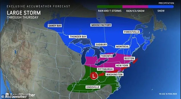
However, Ohio through Pennsylvania, eastern West Virginia, western Maryland and northwestern Virginia are predicted to see the worst weather with significant ice accumulations of up to half an inch.
The National Weather Service (NWS) warned that ‘travel could be nearly impossible’ in those regions and that residents should be prepared for power outages and tree damage from the ice.
AccuWeather senior meteorologist Marshall Moss said that ‘freezing rain is the most dangerous precipitation for travel, there is no traction at all on it.’
He added that ‘ice patches are clear, making it tough for drivers to tell if roads are icy or just wet.’
The ice storm is expected to continue throughout the day and transition to rain by 12pm ET when temperatures reach the upper 30s. Meteorologists said there should be ‘no travel concerns’ around that time.
The icy conditions have also delayed more than 18 flights and canceled 150, according to FlightAware.

A dangerous ice storm is spreading across the northern US, creating hazardous travel conditions and power outage risks through Thursday. Some vehicle accidents have already been reported in Allen County, Kansas

AccuWeather senior meteorologist Marshall Moss said that ‘freezing rain is the most dangerous precipitation for travel, there is no traction at all on it’
More than 100 flights have been cancelled at Philadelphia International Airport alone, and dozens of delays and cancellations are being issued at Reagan National Airport in Arlington, Virginia.
Schools across the Midwest and Northeast have closed or delayed starts today due to the storm, the Weather Channel reported.
That includes hundreds of schools in the Detroit metro area, multiple districts in New York and New Jersey, and some schools in Pennsylvania, Connecticut and Massachusetts.
Winter Storm Freya is currently spreading snow and ice throughout the Appalachians and Northeast.
Snow and sleet are accumulating in New York and New Jersey. As of 7am ET, half an inch had piled up in New York City’s Central Park and in Newark, New Jersey.
Much of the Tri-State area will remain under weather advisories until 1pm ET today,
Wintry precipitation could make for treacherous morning commutes along Interstate 95 from Baltimore, Maryland to Boston, Massachusetts this morning.
As of 9am ET Thursday, more than 55,000 outages were reported in Virginia, as well as over 15,000 in West Virginia and 12,000 in Ohio, according to poweroutage.us.

Up to half an inch of snow and sleet had accumulated in New York City by Thursday morning

Winter storm Freya has already hit parts of more than 20 states and is expected to move into New England later today

The National Weather Service warned that ‘travel could be nearly impossible’ in those regions and that residents should be prepared for power outages and tree damage from the ice. This photo taken in Michigan shows an ice-coated parking lot Thursday morning

The ice storm is expected to continue throughout the day and transition to rain by 12pm ET when temperatures reach the upper 30s. This photo taken in Pennsylvania shows ice-covered driveways Thursday morning
Most of this ice began piling up in parts of Pennsylvania to eastern West Virginia, Maryland and northwestern Virginia morning, making for dangerous morning commutes along Interstates 76, 80, 81 and 90.
Road closures were put in place across much of Pennsylvania.
In West Virginia, thunderstorms and torrential rain have triggered ‘life threatening’ flash flooding.
Officials in several communities have told residents to seek higher ground as the water continues to rise, FOX Weather reported.
Schools across the Midwest and Northeast have closed or delayed starts today due to the storm, the Weather Channel reported

Ice storm warnings are in effect for the central Appalachians from central Pennsylvania to western Virginia to eastern West Virginia
Water rescues have been reported in those areas this morning, and multiple districts have closed their schools or delayed starts today.
Quarter-sized hail battered Kentucky overnight, with people reporting lightning flashes as well.
A tornado watch will remain in effect for the south-central and eastern parts of the state until 11am ET, and there have already been social media reports of possible tornado sightings in the town of Mundfordville.
By the late afternoon, the storm’s impact will expand northeastward into New England, allowing precipitation to taper off and temperatures to rise above freezing in states further south.
However, gusty winds will trail close behind Freya as this storm moves out of the departs the Great Lakes today, with winds upwards of 40 mph picking up from Wisconsin to Michigan, according to AccuWeather.
New England states can expect a few inches of snow to fall into the evening before the storm moves offshore late tonight and high winds move into the region.
On Friday, winds are expected to peak at upper elevations in the Laurel Highlands and northern areas of Pennsylvania before ramping up across the Green and White Mountains in Vermont and New Hampshire.
AccuWeather predicts maximum gusts of up to 65 mph Thursday into Friday.
The winds should die down heading into the weekend, but not for long. Yet another named storm is following close behind Freya, and it’s on track to hit the same regions.


